To truly understand Australia’s ancient landscapes, you first need to walk where the earth echoes its oldest stories. The country’s best bushwalks (Aussie for “hikes”) peel back the millennia, revealing terrain shaped by wind, waves, and 65,000 years of human history. But this land’s deepest connection is felt by those who stay beyond the trail’s last light.
After a day navigating ochre-streaked gorges, ghostly eucalypt forests, or storm-lashed headlands, nothing beats snuggling into your sleeping bag and watching the heavens ignite. Whether you’re chasing Tasmania’s misty alpine sunrises or the Outback’s star-speckled skies, epic overnighters crisscross the continent. We’ve tracked down unforgettable trails, each offering a uniquely Australian adventure.

1. Tabletop Track in Litchfield National Park, Northern Territory
Start and end: Loop trail hikers can access from Florence Falls, Wangi Falls, Walker Creek or Greenant Creek
Length: 39km (24 miles)
Time commitment: 2–3 days
Difficulty level: Moderate
Venture beyond the reach of Darwin’s day-trippers on the Tabletop Track, the traditional land of the Koongurrukun, Mak Mak Marranunggu, Werat and Warray peoples. While Litchfield National Park is famed for its waterfall-fed swimming holes, the trail climbs above the splashy crowds, bringing solitude along the ancient sandstone plateau. Yet, the route isn’t without its refreshing moments. The track follows a string of creekbeds, passing tiered falls and hidden plunge pools, transitioning between eucalypt plains and dense monsoon forests.
The three on-trail campgrounds are bare-bones (bush toilets and fire pits only), but their serenity offsets their simplicity. In particular, the pool-strewn stretch connecting Tjenya Falls Campground and Southern Campground is astonishingly lush, teeming with frogs, lizards, and rainforest birds.
Advertisement
Total elevation gain is minimal (>1000m/3280ft), but don’t underestimate the landscape’s natural obstacles. The sticky heat, loose rocks underfoot, and the irresistible pull of spring-fed swimming holes will slow your progress. Take your time – allow four days or more if you truly want to decompress.
Where to stock up: Load up in Darwin before venturing to remote Litchfield. At a pinch, check petrol stations (sometimes doubling as general stores) along the way for basics.
Need to know: The Tabletop Track is open during the Top End’s dry season (May to September). Visit midweek during peak season (June to August) for fewer crowds.
Don’t forget: Book and pay for campgrounds through NT Parks before you go.
Wrapping it up: Knock the top off a cold one under the verandah at Litchfield’s Wangi Falls Cafe. Here, you’ll find serviceable takeaway fare – coffee, ice cream, sandwiches, wraps and burgers.

2. Thorsborne Trail, in Hichinbrook Island National Park, Queensland
Start and end: Ramsey Bay to George Point
Distance: 32km (19 miles)
Time commitment: 3 days
Difficulty level: Difficult
The Thorsborne Trail is your gateway to the lost-world landscapes of Hinchinbrook Island – Munamudanamy to its Traditional Custodians, the Bandjin and Girramay people. Located between Townsville and Cairns off northern Queensland, most hikers ferry from Lucinda to Ramsay Bay and head south to George Point, the sun at their back, their eyes roaming unhindered over rainforest and coastline.
Winding through the National Park’s varied ecosystems, the demanding trail offers both thigh-thumping climbs and sandy strolls. From the first rugged ascent, a detour to Nina Peak reveals a dramatic island vista – a dense forest interior, an arc of bone-white beach, and the Pacific’s boundless horizon. Keep an eye out for whales migrating north between late August and early September.
Pushing south, the trail reveals more gems – Nina Bay’s shady beach nook, Little Ramsay Bay’s creek-fed lagoon, and an infinity pool teetering above Zoe Falls. The island’s waterholes promise a reprieve from the sun, but they can also attract mosquitoes, sand flies, and march flies, so bring protection. And while a post-hike dip is tempting, estuarine crocodiles occasionally lurk. Stay crocwise.
Where to stock up: Buy your supplies in Townsville or Cairns (both over two hours away); Lucinda Store near the ferry launch point can handle last-minute snacks.
Need to know: The Hinchinbrook ferry is your main expense. Add extra days to your itinerary and make more of the trail’s seven low-cost campsites.
Don’t forget: Camping permits are limited to 40 hikers per day, making peak-season allocations (April to September) hard to come by. Book early!
Wrapping it up: Back on the mainland, schuck back a plate of oysters at the Slipway Bar & Restaurant, Lucinda.

3. Breadknife and Grand High Tops Walk via Bluff Mountain, New South Wales
Start and end: Loop trail from Pincham car park, Warrumbungle National Park
Distance: 16km (10 miles)
Time commitment: 2 days
Difficulty level: Moderate
Rising sharply from New South Wales’ semi-arid plains, Warrumbungle National Park carves a serrated skyline – craggy spires, sheer-walled ridges and monolithic domes shaped by fire and time. The Breadknife and Grand High Tops Walk is the park’s signature bushwalk, balancing steepling ascents with volcanic vistas.
The well-graded path wastes no time gaining elevation through eucalypt forest. If energy permits, detour to one of the side trails for extra lookout opportunities, but save your legs for the looming cliff climb ahead. The path skirts the trachyte face of the dizzying 100m (320ft) Breadknife, then scrambles over Lughs Throne before reaching Grand High Tops. Here, the view explodes outward – rugged escarpments, plunging gullies and distant grazing lands fade to the flattened horizon.
Further on, Dows Camp is ideal for overnight stargazing (albeit without facilities) perched high above the park’s more frequented campgrounds. Come morning, a side trip to Bluff Mountain awaits, rising steadily through clusters of Xanthorrhoea before leveling onto an expansive, all-encompassing summit.
Advertisement
Where to stock up: Collect your shopping from Coonabarabran’s supermarkets; find basic camping supplies at Roach’s Home Timber & Hardware, also in town.
Need to know: Warrumbungle National Park is Australia’s first Dark Sky Park. Check out the nearby Siding Spring Observatory for a world-class astronomy experience.
Don’t forget: The summer heat soars in the Warrumbungles. Bring ample water, protect yourself from the sun, and aim to hike during cooler hours.
Wrapping it up: Head an hour northeast to the remote Pilliga Pottery & Farmstay for unique handcrafted ceramics and wood-fired pizza.
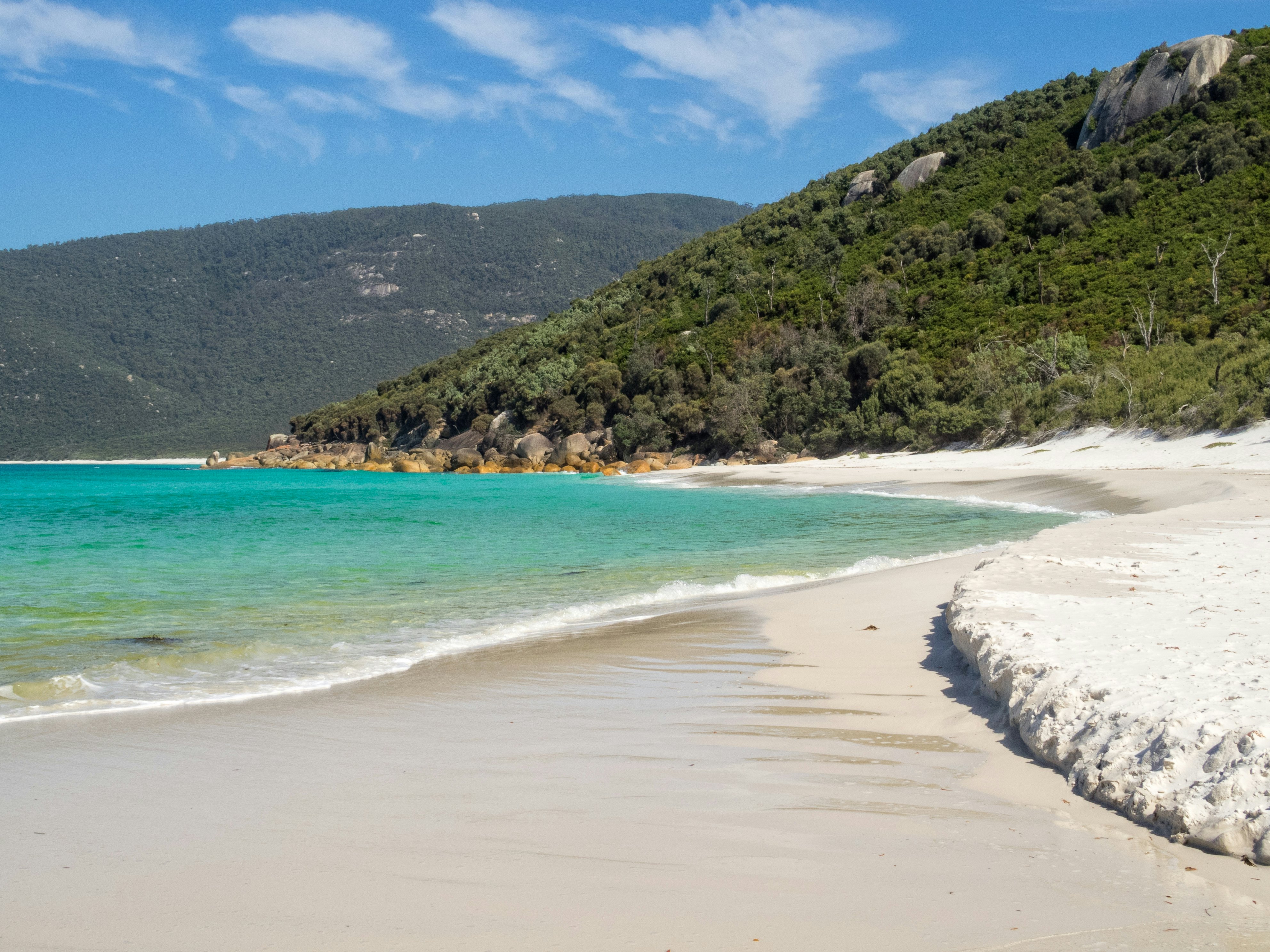
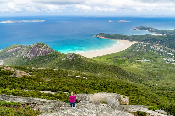
4. Wilsons Prom Southern Circuit, Victoria
Start and end: Loop trail from Telegraph Saddle, Wilsons Promontory National Park
Distance: 58km (36 miles)
Time commitment: 3 days
Difficulty level: Moderate
Clinging to the southernmost toe of mainland Australia, Wilsons Promontory immerses hikers in Victoria’s coastal backcountry. On Boonwurrung Country, “the Prom’s” Southern Circuit winds through wave-battered shores, granite-slabbed headlands, and pockets of temperate rainforest.
Remote camping options here are basic but beautiful (drop toilets, untreated water). Little Waterloo Bay is the standout, its beachfront locale emerging through windswept dunes onto a white-quartz cove.
Expect nature to throw its weight around. Low tide crossings at Sealers Creek chart a rock-strewn path, and the eastern flank steps nimbly through gnarled banksias and sun-bleached tors. Bass Strait’s mood swings whip up stiff ocean gusts and sideways squalls, but your toil is justly rewarded, delivering empty shores, wildlife encounters and solitude in its purest form.
Where to stock up: Melbourne is your best bet for camping supplies, while small-town supermarkets offer provisions on the road south to Wilsons Prom.
Need to know: If you only have one night, detour from Waterloo Bay to Telegraph Junction, bypassing 15km (9 miles) of the park’s southern reaches.
Don’t forget: Collect your camping permits and maps from Tidal River Visitor Centre. You can catch the free shuttle to Telegraph Saddle during peak periods.
Wrapping it up: Make a pit stop at the Meeniyan Hotel on your way back to Melbourne, a century-old institution peddling hearty country fare.

5. Walls of Jerusalem, Tasmania
Start and end: Loop trail from car park near Fish River, Walls of Jerusalem National Park
Distance: 22km (14 miles)
Time commitment: 2–3 days
Difficulty level: Difficult
Tasmania’s Walls of Jerusalem National Park is an amphitheater of ancient dolerite, a highland stronghold accessible only to those willing to shoulder a pack and climb into its mountainous realm. Pack your hardiest boots for this one. The track demands self-sufficiency – no road access, no luxuries, just raw Tasmanian wilderness.
The trail’s first climb onto an alpine plateau unveils a valley of biblical proportions, both in name and grandeur. Towering rock formations dubbed the “Walls” loom large, with Solomon’s Throne and King David’s Peak reigning over moorland flecked with cushion plants and scoparia.
Though the distances aren’t daunting, the terrain can be unforgiving – boulder fields, boggy plains and Tasmania’s trademark fickle weather can slow your journey. Summer snow flurries aren’t unthinkable. For extra steps, climb Mt Jerusalem to find sweeping Central Highlands views or detour to the Pool of Bethesda, reflecting stone and sky.
Where to stock up: Tasmania’s northwest offers few supply points. You can find food, fuel and gear in Launceston, two hours away.
Need to know: Wild Dog Creek is the park’s only formal campsite, with tent platforms, toilets and a rainwater tank. Elsewhere, setup away from water sources to prevent erosion and contamination.
Don’t forget: To protect your gear and the local wildlife (particularly tent-shredding brushtail possums), store all food and rubbish in sealed containers.
Wrapping it up: Rejoin civilization at Bush Inn Brewhouse, Deloraine, for sourdough pizza and locally brewed ales.

6. Alligator Gorge to Mambray Creek, South Australia
Start and end: Out-and-back trail from Alligator Gorge car park, Mt Remarkable National Park
Distance: 28km (17 miles)
Time commitment: 2 days
Difficulty level: Moderate
Tucked into the Southern Flinders Ranges ancient folds, the route linking Alligator Gorge to Mambray Creek delivers Mt Remarkable National Park’s most iconic geological marvels. On Ngadjuri and Nukunu land, this trail network meanders through the mallee scrub, rising above craggy escarpments that have formed over millennia.
The path appears deceptively simple. But the track takes its time, rippling between cleaved creekbeds and forested plateaus. The park’s most famous landmark, Alligator Gorge, carves through the bush, with its sharp bends and fissured gullies conjuring a sinuous reptilian form (rest assured, no crocs lurk here).
Here, summer’s dry heat beats down, with no cool waters for relief. Instead, the eucalypt canopy offers a shady companion along much of the path. There are enough campsites and car parks to choose your own adventure, but don’t overlook the indulgence of a hot mid-hike shower at Mambray Creek.
Where to stock up: Grab camping and food supplies from Adelaide before driving up; Store 54 in nearby Melrose caters to last-minute snacks.
Need to know: The Hidden Gorge hike loops 17km (11 miles) around Mambray Creek. Consider staying two nights here to explore the dramatic sandstone chasm.
Don’t forget: Phone reception is often spotty and inconsistent, particularly in low-lying areas. Download maps before dipping into the park’s gorges.
Wrapping it up: Relax and recharge with a cold craft brew at Jacka Brothers Brewery, Melrose.

7. Murchison Gorge Track, Western Australia
Start and end: End-to-end trail from Ross Graham Lookout to the Loop, Kalbarri National Park
Distance: 38km (24 miles)
Time commitment: 3–5 days
Difficulty level: Difficult
Home to WA’s Nanda people, Murchison Gorge plunges into a 400-million-year-old cavity of Tumblagooda Sandstone. Striated cliffs rise high, bearing a geological reminder of inland seas and ancient waterways.
Carving through Wurdimarlu/Kalbarri National Park, this track is a test of endurance – soft sand, loose scree and summer’s furnace-like heat ensure that every step is earned. There are few markers, no creature comforts and no formal campsites, just raw, remote terrain that demands thorough preparation, route-finding skills and river-crossing experience (after a decent rainfall). Yet, the rewards are immense. Hidden waterholes glint between ochre-hued chasms, as winding bends meander through the desiccated landscape, framed by ghost gums and sculpted overhangs.
The complete Murchison Gorge Track demands experience, but the Loop trail encircling its northern trailhead offers a more manageable adventure. Starting near Nature’s Window, a postcard-perfect rock arch with sweeping views, this 9km (5.5-mile) circuit delivers a gratifying taste for far less grind.
Where to stock up: Grab your gear in Perth before making the six-hour drive north to Kalbarri. If you’re light on camping gear, try Kalbarri Sports & Dive for the basics.
Need to know: Water sources in the gorge are unreliable through the warmer months. Plan to carry at least two days’ supply.
Don’t forget: Register your overnight hike at Kalbarri Park headquarters before setting off.
Wrapping it up: Little Leaf Kalbarri serves up Mexican-inspired favorites and great coffee with a stunning ocean view – perfect for post-hike sustenance.